Long Range Planning
Adopted Plans
View the Harnett County Adopted Plans.


Harnett Horizons 2040 Comprehensive Land Use Plan
The Harnett Horizons 2040 Comprehensive Land Use Plan was adopted April 29, 2025. View the plan here.
View the Future Land Use Map
Click here to view the Village District Design Concept Guidelines
![]()
North Harnett Transit Study
Share Your Thoughts at Upcoming Events, Feedback Survey
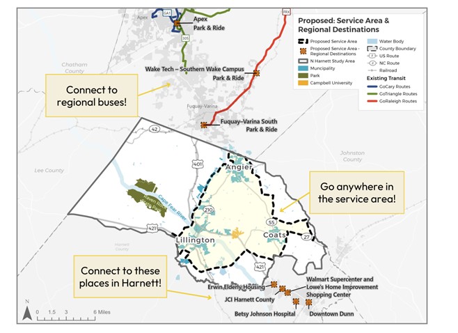
The North Harnett Transit Study proposed transit solution for one of our region’s highest growth areas is microtransit with connections to regional destinations. Launched in November 2023 by the N.C. Capital Area Metropolitan Planning Organization (CAMPO) and Harnett County, the study has evaluated the public’s need and support for transit in the portion of northern Harnett County, N.C. that overlaps with the CAMPO boundary, including Angier, Lillington, Coats, Buies Creek, Raven Rock State Park, and Campbell University.
Microtransit with Regional Connections
Based on community feedback and transit/demographic data, the proposed recommendation is a hybrid model: Microtransit within a proposed service area combined with connections to or from a set of nearby destination options. This would include three Park & Rides north of Harnett County that provide connections to existing transit services in Wake County, as well as popular services and shopping centers to the south.

More on Microtransit
Microtransit combines traditional bus service with ridesharing, allowing riders to travel anywhere within the service area. All of this on their own schedule! Users request a ride in real-time using a smartphone app, website, or phone call. It's flexible, convenient, reliable, and open to everyone!
Additional information is available in this brochure.
Study Background
As North Harnett County continues to experience increased growth and development, exploration of various mobility options, such as public transit, is underway. The North Harnett Transit Study has aimed to identify transit needs and provide transit service recommendations for the portion of Harnett County that includes Angier, Lillington, Coats, Buies Creek, Raven Rock State Park, and Campbell University.
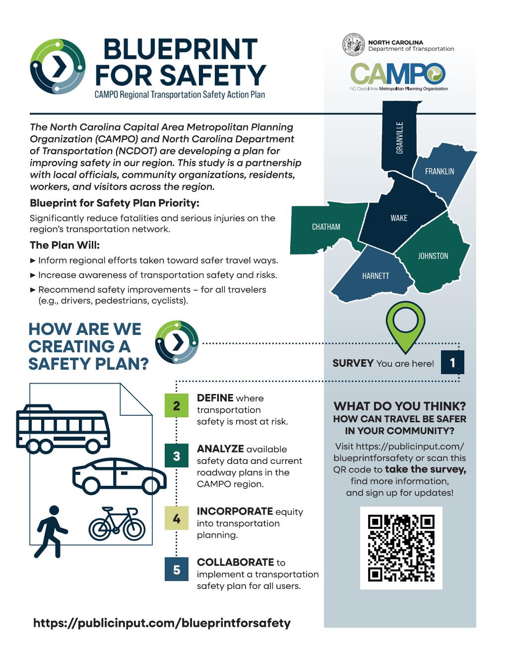
CAMPO Blueprint for Safety
US 401 Corridor Study

|
|||
|
|
|||
|
FAMPO: Sandhills Safe & Connected 2050 Metropolitan Transportation Plan
2050 Metropolitan Transporation Plan Executive Summary
![]()
2020 Harnett Bicycle, Pedestrian, & Greenway Master Plan

2020-2029 State Transportation Improvement Plan (STIP)
The N.C. Department of Transportation's transportation plan – called the State Transportation Improvement Program (STIP) – identifies the construction funding and schedule for state transportation projects over a 10-year period. NCDOT updates the STIP approximately every two years to reflect the state's current financial situation.

2018 North West Area Plan
Harnett County has completed the process to create a Small Area Plan for the northwestern part of the County. The plan focused on the area between NC 210 to the east, the Cape Fear River to the south and the Wake County line to the north. The population of this area has grown by 56% since the year 2000. It remains primarily rural in nature but is increasingly experiencing increased growth pressure expanding from Fuquay-Varina and Wake County.
This planning effort will build on policies in the 2015 Comprehensive Growth Plan and focus on balancing the rural character of the area while accommodating growth and determining infrastructure needs. The outcome of this plan will be a revised land use plan to guide rezonings and recommendations that will guide public and private investment decisions for years to come. It is anticipated that this planning process will take approximately six months.

Sandhills Regional Bicycle Plan
The Sandhills Regional Bicycle Plan covers Cumberland, Harnett, Hoke, Scotland and Robeson Counties and parts of Bladen and Sampson Counties.
The Fayetteville Area Metropolitan Planning Organization (FAMPO) was awarded a planning grant from the North Carolina Department of Transportation (NCDOT) to develop a regional comprehensive bicycle transportation plan. The overall goal of the Project is to provide a framework for NCDOT and local governments to enhance bicycling as a mode of transportation for residents and visitors alike, improving access, connectivity, and safety.

Comprehensive Transportation Plan
A comprehensive transportation plan works in many ways the same as a long range plan; however it is used to plan for the future transportation needs of a community. Many people immediately think of motorized-vehicular transportation when they hear the term 'transportation'; however there many other forms of transportation, including pedestrian, bicycle, and public transit. With a comprehensive transportation plan in place, as development occurs the planned future transportation updates are made.
Harnett County worked with several other agencies to develop a comprehensive transportation plan for our community. Below you will find a link from the NC Department of Transportation for Harnett County. Click here to view the plan.
